I had fully intended not to run at all in Penzance and give my legs a thorough rest after Bath (except for walking). But after dinner last night, which ended with ice cream topped with clotted cream (I kid you not), after a day almost entirely spent sitting on a train, I rethought my plans and decided to take the old legs out for a test drive this morning.
Ow, ow, ow. My hips scolded me reproachfully as I took my first few steps out of the Abbey Hotel courtyard. A few steps, then a stop. Look at the map and change directions. A few more achy steps, this time in the right direction. This could be a really hard, as in difficult, run! Of course it didn't help that these first few steps were uphill on a cobbled street. Nothing like uneven stone paving to jostle your joints!
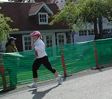
 My destination was the Promenade, a wide paved walkway that ran along the seafront in Penzance. And when I finally got out of the side streets and down to the Promenade, I was rewarded with a smooth, flat surface to run on. While it still wasn't easy, or anything like fast, at least it wasn't out and out painful, and there was much less chance of a sprained ankle.
My goal for this morning was to go no more than five miles, and no less than four miles. After my, ahem, rocky beginning, I quickly determined that two miles out and two miles out would make an adequate distance. Plus I wasn't sure how far my walkway would go.
The Promenade itself, I determined, ran about half a mile in the direction I was heading before it turned into more of a paved bike path (still an adequate running surface). About a mile out of Penzance I came to the end of that path as well in a small town called Newlyn. In Newlyn I picked my way through town, hopping between narrow sidewalks that seemed to alternate from one side of the street to the other, and into the narrow street where there was no sidewalk at all. At that time of morning, around 7 a.m., there were few cars in the street to jump out of the way of.
Outside of Newlyn the sidwalks became a bit wider, although still seemed to alternate between sides. After a bit, though, I followed a footpath through a row of small houses terraced along the seaside, and from there onto an honest to goodness paved bike path, which led me to the two-mile point (a little past, in fact). It also led me to a scenic roadsign which proclaimed “Penzance 2 miles” (back where I had come from).
It also proclaimed the distance to a village called Mousehole (pronounced “Mowzzle”), and upon reflection, I am wondering what distance it actually said. I left with the impression that Mousehole was three miles from Penzance, which would mean the sign said one mile from where I was standing. But now I am thinking that perhaps the sign said “Mousehole 3 miles” instead. I had tentatively planned to extend my distance to Mousehole on Thursday morning, and if it is six miles round trip that is a reasonable plan. But if it is a total of five miles each way—well, I'm not running ten miles on Thursday morning, that's for sure. We shall see. (I googled the distance and I was right the first time, so the plan is back on.)
I turned around and followed the paths and roads back into Penzance, and by the time I wound my way through some side streets and back to the hotel courtyard, I manage to up my total mileage to 4.75 miles—a respectable total for the first run back out. My Garmin also claimed I burned 530 calories* which, although barely a dent in the food we've been consuming, is at least something.
Tomorrow morning I'm not running; my plan is to take a walk along the Cornish Coastal Path and meet my parents in St. Ives.
To see more pictures from the day in Penzance, click here. To read about the rest of the day, click here.
*I know that is not net calories, but on the other hand, the weight programmed into the Garmin, which is used to calculate the calorie consumption, is not my current weight either.


No comments:
Post a Comment